🇧🇩

Bangladesh

South Asia Countries
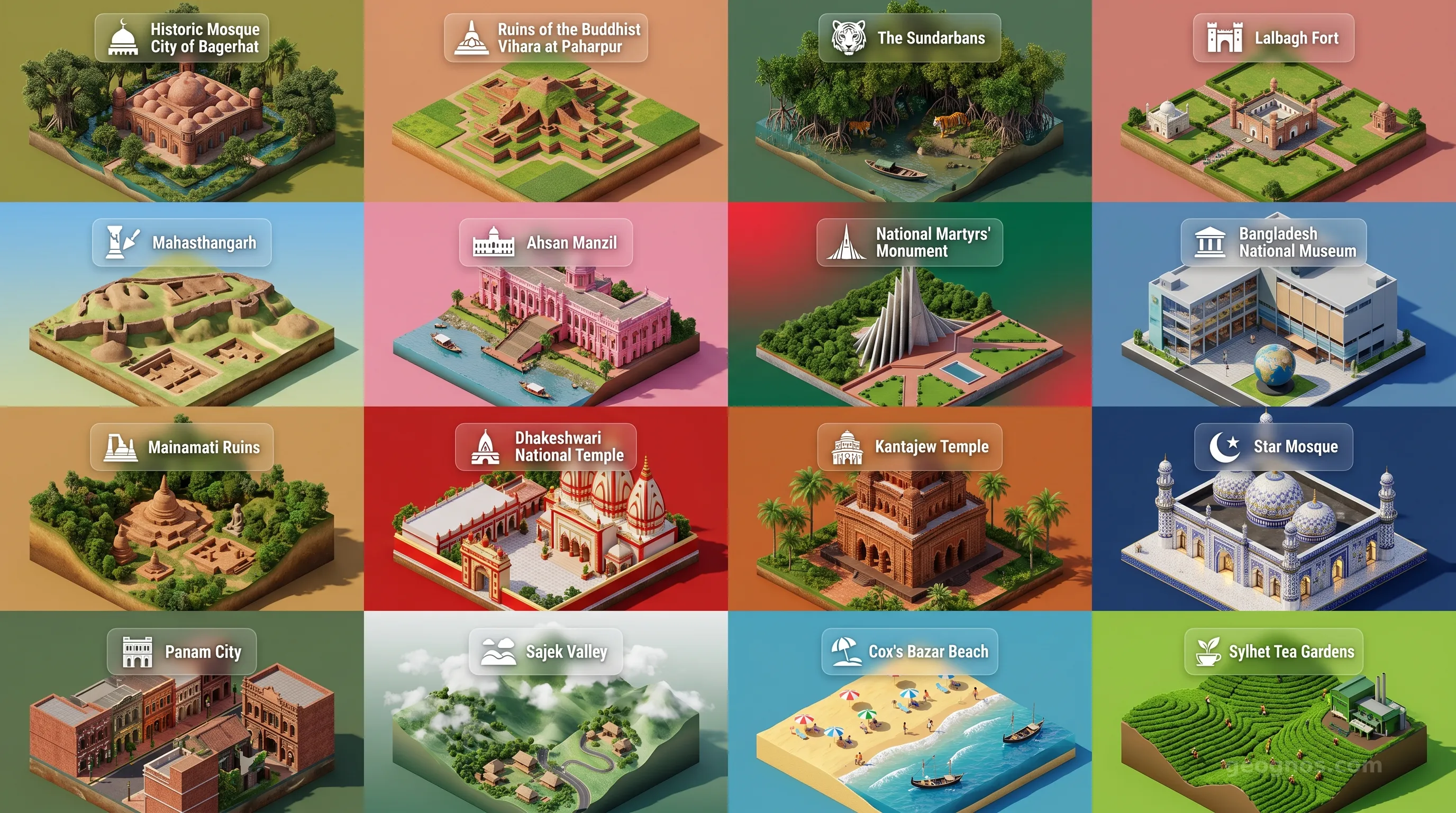
Bangladesh - Panoramic Places of Interest Atlas including Historic Mosque City of Bagerhat, Ruins of the Buddhist Vihara at Paharpur, The Sundarbans, Lalbagh Fort, Mahasthangarh, Ahsan Manzil, National Martyrs' Monument, Bangladesh National Museum, Mainamati Ruins, Dhakeshwari National Temple, Kantajew Temple, Star Mosque, Panam City, Sajek Valley, Cox's Bazar Beach, Sylhet Tea Gardens

Top Sights & Landmarks

01

Historic Mosque City of Bagerhat

15th-Century Islamic Metropolis

02

Ruins of the Buddhist Vihara at Paharpur

Ancient Buddhist Monastery

03

The Sundarbans

World's Largest Mangrove Forest

04

Lalbagh Fort

Unfinished 17th-Century Mughal Complex

05

Mahasthangarh

Oldest Urban Archaeological Site in Bangladesh

06

Ahsan Manzil

The Pink Palace of Dhaka

07

National Martyrs' Monument

Iconic Memorial of the Liberation War

08

Bangladesh National Museum

Premier Repository of Bengali Heritage

09

Mainamati Ruins

Remnants of the Samatata Kingdom

10

Dhakeshwari National Temple

12th-Century State Temple of Bangladesh

11

Kantajew Temple

Masterpiece of Terracotta Architecture

12

Star Mosque

Ornate Mosaic Mosque (Tara Masjid)

13

Panam City

Abandoned 19th-Century Merchant City

14

Sajek Valley

The Roof of Rangamati

15

Cox's Bazar Beach

World's Longest Natural Sea Beach

16

Sylhet Tea Gardens

The Tea Capital of Bangladesh

The Land of Eternal Flow: Understanding the Pulse of Bangladesh

To understand Bangladesh, one must first look at a map not as a static collection of borders, but as a living organism sculpted by the tireless work of water. Here, the landscape is not merely a stage for human activity, but the principal protagonist of the national narrative. Defined by the grand convergence of the Ganges, the Brahmaputra, and the Meghna rivers, Bangladesh is the world's greatest delta. It is a land where the boundary between earth and water is perpetually blurred, and where life adapts, thrives, and innovates in harmony with the rhythm of the tides and seasons.

This is a nation that embodies the concept of "fluidity." From the emerald-green paddy fields that transform into shimmering inland seas during the monsoon to the intricate web of waterways that serve as the country’s primary arteries of commerce and communication, the environment dictates the character of the people. Visitors arriving on the soil of Bangladesh often describe a sensation of being in a place where history is being constantly rewritten by the very silt carried down from the Himalayas, creating a nation that is both ancient in its cultural roots and remarkably youthful in its demographic energy.

A Tapestry Woven from Deltaic Soil

The geography of Bangladesh is unique on the global stage. It is a low-lying, flat terrain where millions of people coexist with one of the most dynamic hydraulic systems on Earth. Yet, to see it only as a collection of rivers is to miss the human spirit that resides here. This is a region that has served as a crucible of civilization for millennia, witnessing the rise and fall of empires, the influence of great religions, and the enduring resilience of agrarian traditions. To appreciate the layers of time that have shaped this nation, one can explore the comprehensive history of Bangladesh, which chronicles the transitions from ancient regional kingdoms to the modern identity that stands today.

The nation's architectural and cultural landscape reflects this storied past. Whether it is the terracotta ornamentation of medieval temples or the stark, impressive brutalism of modern public buildings in Dhaka, the visual identity of the country is as complex as its geography. For those who wish to experience this visual chronology, we recommend viewing our history cinematic showcase, which brings pivotal moments in the nation's timeline to life through meticulously curated illustrations and expert summaries.

The Living Rhythm of Resilience

If you ask a resident of the rural riverine districts how they perceive their home, they might point toward the seasonal floods not as disasters, but as the heartbeat of the land. The alluvial soil, replenished every year, makes this region one of the most fertile areas on the planet. This agricultural bounty has supported a dense and vibrant population for centuries, fostering a culture of community and interdependence that remains strong to this day. The social fabric of Bangladesh is a masterpiece of hospitality, defined by an openness that welcomes travelers into a world of vibrant music, colorful festivals, and deep-seated literary traditions.

Education is at the core of our mission at GeoGnos, and we believe that interacting with the past is the best way to prepare for the future. We encourage students and curious travelers to challenge their understanding of the region by attempting our interactive history puzzle, a chronological brain-teaser designed to reward users as they correctly order the seminal events that carved the path for the modern state. It is an engaging way to internalize the narrative flow of a country that refuses to stand still.

From Sundarbans to Bustling Dhaka

While the internal river systems define the country, the periphery offers a landscape of staggering diversity. In the southwest lies the Sundarbans, the world's largest contiguous mangrove forest and a UNESCO World Heritage site. It is a mystical place where the royal Bengal tiger prowls through the tangle of sundari trees, and where the saline winds meet the freshwater currents in a delicate, protected ecosystem. To the northeast, the terrain shifts into the rolling tea gardens of Sylhet, draped over hills that offer a serene contrast to the plains below.

Bangladesh is an essential stop for the global explorer precisely because of this variety. Whether one is trekking through the verdant heights of the Chittagong Hill Tracts or navigating the bustling, color-drenched river ports of the capital, the sensory input is intense and life-affirming. To help prospective travelers and armchair explorers alike visualize these distinct destinations, we have compiled an immersive POI cinematic showcase. This carousel player highlights the geographic and cultural landmarks that define the essence of the country, offering a guided view into the hidden gems of this deltaic nation.

A Future Written in Water and Light

As Bangladesh moves through the twenty-first century, it stands as a testament to the power of human ingenuity. Facing the challenges of a changing environment with characteristic grit, the nation has become a global leader in innovative adaptation strategies, community-based climate initiatives, and small-scale entrepreneurship. The story of Bangladesh is, ultimately, the story of humanity's ability to innovate when living in the closest proximity to the elements. It is a nation that moves with the currents of history rather than against them, always finding new ways to harvest the sun, the soil, and the water.

We invite you to delve deeper into these sections—to study the demographics of its population, the intricacies of its governance, and the vital stats of its growing economy—to get a holistic view of a country that is clearly destined to play an increasingly significant role on the global stage. Bangladesh is not just a destination. It is a profound lesson in geography, history, and the relentless endurance of the human spirit. Welcome to our deep dive into the soul of the delta.

Location

Latitude
24° N
Longitude
90° E
N S W E
World Map Location
Geographic Location

Southern Asia, bordering the Bay of Bengal, between Burma and India

Map Reference
Asia

Area

Total Area
148,460 sq km
Land (88%)
Land: 130,170 sq km
Water: 18,290 sq km

Elevation

Highest Point
Mowdok Taung
Mowdok Taung 1,060 m
Lowest Point
Bay of Bengal
Bay of Bengal 0 m
Mean Elevation
85 m

Detailed Geography Information

Coastline

580 km

Geography - note

most of the country is situated on deltas of large rivers flowing from the Himalayas: the Ganges unites with the Jamuna (main channel of the Brahmaputra) and later joins the Meghna to eventually empty into the Bay of Bengal

Irrigated land

83,690 sq km (2022)

Land boundaries

Total boundary: 4,413 km
Burma 271 km
India 4142 km

Major aquifers

Indus-Ganges-Brahmaputra Basin

Major rivers (by length in km)

Brahmaputra river mouth (shared with China [s] and India) - 3,969 km; Ganges river mouth (shared with India [s]) - 2,704 km note: [s] after country name indicates river source; [m] after country name indicates river mouth

Major watersheds (area sq km)

Indian Ocean drainage: Brahmaputra (651,335 sq km), Ganges (1,016,124 sq km)

Maritime claims

territorial sea: 12 nm contiguous zone: 18 nm exclusive economic zone: 200 nm continental shelf: to the outer limits of the continental margin

Natural hazards

droughts; cyclones; much of the country routinely inundated during the summer monsoon season

Natural resources

natural gasarable landtimbercoal

Terrain

mostly flat alluvial plain; hilly in southeast

Population & Growth

+0.90% Growth
174,370,536
Total inhabitants (2025 est.)
Male: 48.1% (83,908,720) Female: 51.9% (90,461,816)

Age Distribution

0-14 years
25.1%
~43,767,005
15-64 years
67.1%
~117,002,630
65 years
7.8%
~13,600,902
Note: 2024 est.

Demographic Longevity

Median Age
27.8 years
Male
28.7 yrs
Female
30.4 yrs
Life Expectancy
75.2 years
Male
73.1 yrs
Female
77.5 yrs

Vital Dynamics

Birth Rate
19.45
births per 1,000 people
Death Rate
6.05
deaths per 1,000 people
Net Migration
-4.28
migrants per 1,000 people
Fertility Rate
2.25
children born per woman

Detailed People & Society Information

Alcohol consumption per capita

0 liters of pure alcohol (2019 est.)

Children under the age of 5 years underweight

21.7% (2022 est.)

Currently married women (ages 15-49)

80.6% (2022 est.)

Dependency ratios

total dependency ratio: 54.6 (2025 est.) youth dependency ratio: 43.5 (2025 est.) elderly dependency ratio: 11.1 (2025 est.) potential support ratio: 9 (2025 est.)

Education expenditure

2%

2% of GDP (2024 est.) 11.9% national budget (2025 est.)

Ethnic groups

Bengali at least
99%
other indigenous ethnic groups
1%

Gross reproduction rate

1.1 (2025 est.)

Health expenditure

2.4%

2.4% of GDP (2021) 1.2% of national budget (2022 est.)

Hospital bed density

0.9 beds/1,000 population (2019 est.)

Infant mortality rate

total: 22 deaths/1,000 live births (2025 est.) male: 31.3 deaths/1,000 live births female: 26.3 deaths/1,000 live births

Languages

Bangla
98.8%
other
1.2%

Literacy

total population: 79% (2022 est.) male: 81.4% (2022 est.) female: 76.5% (2022 est.)

Major urban areas - population

23.210 million DHAKA (capital), 5.380 million Chittagong, 955,000 Khulna, 962,000 Rajshahi, 964,000 Sylhet, 906,000 Bogra (2023)

Maternal mortality ratio

115 deaths/100,000 live births (2023 est.)

Mother's mean age at first birth

18.6 years (2017/18 est.) note: data represents median age at first birth among women 20-49

Nationality

noun: Bangladeshi(s) adjective: Bangladeshi

Obesity - adult prevalence rate

3.6% (2016)

Physician density

0.72 physicians/1,000 population (2023)

Refugees and internally displaced persons

Total Displaced & Vulnerable Persons
2,767,900 individuals
Refugees
36.3%
1,005,637
1,005,637 (2024 est.)
Internally Displaced Persons (IDPs)
27.3%
756,743
756,743 (2024 est.)
Stateless Persons
36.3%
1,005,520
1,005,520 (2024 est.)

Religions

Muslim
91%
Hindu
8%
other
1%

School life expectancy (primary to tertiary education)

total: 11 years (2023 est.) male: 11 years (2023 est.) female: 12 years (2023 est.)

Sex ratio

at birth: 1.04 male(s)/female 0-14 years: 1.04 male(s)/female 15-64 years: 0.95 male(s)/female 65 years and over: 0.87 male(s)/female total population: 0.96 male(s)/female (2024 est.)

Tobacco use

total: 29.7% (2025 est.) male: 47.6% (2025 est.) female: 12.5% (2025 est.)

Climate & Issues

Climate Profile

tropical; mild winter (October to March); hot, humid summer (March to June); humid, warm rainy monsoon (June to October)

Key Environmental Issues
flooding water pollution, especially of fishing areas, from the use of commercial pesticides groundwater pollution from naturally occurring arsenic falling water tables in the northern and central parts of the country soil degradation and erosion deforestation destruction of wetlands severe overpopulation with noise pollution

Land Cover

Coverage Distribution
Agri (72%)
Arable: 60.6%
Crops: 7.1%
Pasture: 4.6%
Forest: 14.4%

Air & Carbon Emissions

Annual CO2 Output 2023 est.
125.956 million
Coal (21%) Oil (33%) Gas (45%)
PM2.5 Exposure 42.5 µg/m³
0 5 (WHO Limit) 15 25 35+
Methane Emissions
energy: 544 kt (2022-2024 est.)

Water Resources & Use

Renewable Water Resources 1.227 trillion cubic meters (2022 est.)
Annual Water Withdrawal
municipal: 3.6 billion cubic meters (2022 est.)
Municipal (10%) Ind (2%) Agri (88%)

Detailed Environmental Information

International environmental agreements

BiodiversityClimate ChangeClimate Change-Kyoto ProtocolClimate Change-Paris AgreementComprehensive Nuclear Test BanDesertificationEndangered SpeciesEnvironmental ModificationHazardous WastesLaw of the SeaNuclear Test BanOzone Layer ProtectionShip PollutionWetlands

Urbanization

urban population: 40.5% of total population (2023) rate of urbanization: 2.88% annual rate of change (2020-25 est.)

Waste and recycling

municipal solid waste generated annually: 14.778 million tons (2024 est.) percent of municipal solid waste recycled: 15.7% (2022 est.)

Capital & State Profile

Capital City
Dhaka
23.7167° N, 90.4° E
Timezone UTC+6
Government Type
parliamentary republic
Independence 1971-12-16
National Holiday 03-26

Executive Branch

Chief of State
President Mohammad SHAHABUDDIN Chuppi (since 24 April 2023)
Head of Government
Interim Prime Minister Muhammad YUNUS (since 8 August 2024)
Last Election 13 February 2023
Next Election 2028
Cabinet Cabinet selected by the prime minister, appointed by the president

Legislative Branch

Seats & Term
N/A seats / N/A
Electoral System N/A

National Identity & Symbols

National Flag Description

green field with a large red disk shifted slightly to the left

Symbolic Meaning the red disk represents the rising sun and the sacrifice to achieve independence; the green field symbolizes the lush vegetation of Bangladesh
National Symbol Bengal tiger, water lily
National Colors green, red
National Anthem Amar Shonar Bangla (My Golden Bengal)

Detailed Government Information

Administrative divisions

8 divisions; Barishal, Chattogram, Dhaka, Khulna, Mymensingh, Rajshahi, Rangpur, Sylhet

Citizenship

citizenship by birth: no citizenship by descent only: at least one parent must be a citizen of Bangladesh dual citizenship recognized: yes, but limited to select countries residency requirement for naturalization: 5 years

Constitution

history: previous 1935, 1956, 1962 (pre-independence); latest enacted 4 November 1972, effective 16 December 1972, suspended March 1982, restored November 1986 amendment process: proposed by the House of the Nation; approval requires at least two-thirds majority vote of the House membership and assent of the president of the republic

Country name

conventional long form: People's Republic of Bangladesh conventional short form: Bangladesh local long form: Gana Prajatantri Bangladesh local short form: Bangladesh former: East Bengal, East Pakistan etymology: the name is a compound of the Bengali words Bangla (Bengali) and desh (country)

International law organization participation

has not submitted an ICJ jurisdiction declaration; accepts ICCt jurisdiction

International organization participation

Judicial branch

highest court(s): Supreme Court of Bangladesh (organized into the Appellate Division with 7 justices and the High Court Division with 99 justices) judge selection and term of office: chief justice and justices appointed by the president; justices serve until retirement at age 67 subordinate courts: civil courts include: Assistant Judge's Court; Joint District Judge's Court; Additional District Judge's Court; District Judge's Court; criminal courts include: Court of Sessions; Court of Metropolitan Sessions; Metropolitan Magistrate Courts; Magistrate Court; special courts/tribunals

Legal system

common law, incorporating elements of English common law; since independence, statutory law has been the primary form of legislation; Islamic law applies to Muslims in family and inheritance laws, with Hindu personal law applying to Hindus and Buddhists

National heritage

total World Heritage Sites: 3 (2 cultural, 1 natural) selected World Heritage Site locales: Bagerhat Historic Mosque (c); Ruins of the Buddhist Vihara at Paharpur (c); Sundarbans (n)

Political parties

Awami League or AL Bangladesh Jamaat-i-Islami or JIB Bangladesh Nationalist Party or BNP Islami Andolan Bangladesh Jatiya Party or JP (Ershad faction) Jatiya Party or JP (Manju faction) National Socialist Party (Jatiya Samajtantrik Dal) or JSD Workers Party or WP

Suffrage

18 years of age; universal

Economic Overview

one of the fastest growing emerging market economies; strong economic rebound following COVID-19; significant poverty reduction; exports dominated by textile industry; weakened exports and remittances resulted in declining foreign exchange reserves and 2022 IMF loan request

Size & Performance

Real GDP (PPP)
$1.473 trillion
Latest available estimate (2024)
2023: $1.413 trillion2022: $1.336 trillion
Real GDP Growth
4.2% (2024 est.)
+4.2%
GDP Per Capita (PPP)
$8,500
2023: $8,2002022: $7,900

GDP Sector Breakdown

Agriculture: 11.2%Industry: 34.1%Services: 51.4%
Origin GDP %
Agriculture 11.2%
Industry 34.1%
Services 51.4%

Trade Balance

Trade Position
Trade Deficit
$21.11 billion
Total Exports
$53.848 billion (2024 est.)
Total Imports
$74.96 billion (2024 est.)
Exports (42%) Imports (58%)

Budget Balance

Budget Position
Budget Deficit
-$11.71 billion
Revenues
$39.849 billion (2021 est.)
Expenditures
$51.558 billion (2021 est.)
Revenues (44%) Expenditures (56%)

Export Profile

Top Export Partners

16.0%
8.0%
7.0%
Note: 2023; top five export partners based on percentage share of exports

Major Export Commodities

garmentsfootwearfabrictextilestrunks and cases

Import Profile

Top Import Partners

Note: 2023; top five import partners based on percentage share of imports

Major Import Commodities

refined petroleumcotton fabricnatural gascottonfabric

Labor & Employment

Total Labor Force 77.355 million (2024 est.)
General Unemployment Rate 4.7%
Youth Unemployment (Ages 15-24) 11.5%
Population Below Poverty Line 18.7% (2022 est.)

Income Inequality

Gini Coefficient (Family Income) 33.4
0 (Perfect Equality) Moderate Inequality 100 (Perfect Inequality)

Family Income / Consumption Share

Lowest 10%: 3.5% (2022 est.) Highest 10%: 27.4% (2022 est.)
Inequality Gap: Top 10% holds 7.8x the share of the bottom 10%.

Detailed Economic Data

Agricultural products

ricemilkpotatoesmaizesugarcaneonionsjutevegetablesmangoestropical fruits

Current account balance

$1.87 billion (2024 est.) $4.388 billion (2023 est.) -$14.438 billion (2022 est.) note: balance of payments - net trade and primary/secondary income in current dollars

Debt - external

$58.02 billion (2023 est.) note: present value of external debt in current US dollars

Exchange rates

taka (BDT) per US dollar - Exchange rates: 115.604 (2024 est.) 106.309 (2023 est.) 91.745 (2022 est.) 85.084 (2021 est.) 84.871 (2020 est.)

GDP - composition, by end use

Industrial production growth rate

3.5% (2024 est.) note: annual % change in industrial value added based on constant local currency

Industries

cottontextiles and clothingjuteteapapercementfertilizersugarlight engineering

Inflation rate (consumer prices)

10.5% (2024 est.) 9.9% (2023 est.) 7.7% (2022 est.) note: annual % change based on consumer prices

Remittances

6% of GDP (2024 est.) 5.1% of GDP (2023 est.) 4.7% of GDP (2022 est.) note: personal transfers and compensation between resident and non-resident individuals/households/entities

Reserves of foreign exchange and gold

$21.395 billion (2024 est.) $21.86 billion (2023 est.) $33.747 billion (2022 est.) note: holdings of gold (year-end prices)/foreign exchange/special drawing rights in current dollars

Taxes and other revenues

7.6% (of GDP) (2021 est.) note: central government tax revenue as a % of GDP

Grid Infrastructure

Electricity Access 99.4%
Urban: 100% Rural: 99.3%
Capacity 22.699 million kW (2023 est.)
Consumption 107.285 billion kWh (2023 est.)
Imports 9.407 billion kWh (2023 est.)
Grid Losses: 8.279 billion kWh (2023 est.)

Generation Mix

Percentage Share of Production
fossil fuels 98.4%
solar 1%
hydroelectricity 0.6%

Fossil Fuels Production

Petroleum
Production 13,000 bbl/day (2023 est.)
Consumption 263,000 bbl/day (2023 est.)
Proven Reserves 28 million barrels (2021 est.)
Natural Gas
Production 22.334 billion cubic meters (2023 est.)
Consumption 29.119 billion cubic meters (2023 est.)
Imports 6.785 billion cubic meters (2023 est.)
Proven Reserves 126.293 billion cubic meters (2021 est.)
Coal
Production 767,000 metric tons (2023 est.)
Consumption 14.05 million metric tons (2023 est.)
Imports 13.305 million metric tons (2023 est.)
Proven Reserves 3.26 billion metric tons (2023 est.)

Intensity & Nuclear

Energy Consumption Per Capita 11.472 million Btu/person (2023 est.)
Nuclear Power Profile
Operational Reactors 2

Digital Access

.bd
Internet Usage 45%

Active internet users as a percentage of the total population.

Fixed Broadband

Penetration Rate 8 / 100
Total Subscriptions 12.9 million (2023 est.)

Mobile Cellular

Penetration Rate 108 / 100
Total Subscriptions 188 million (2024 est.)

Broadcast Media

state-owned Bangladesh Television (BTV) broadcasts nationally; some channels operate via satellite; the government also owns a medium-wave radio channel and some private FM radio news channels; of the 41 approved TV stations, 26 are currently being used to broadcast, and 23 operate under private management via cable distribution

Aviation

S2
Airports
17
As of 2025
Heliports
36
As of 2025

Railways

Total Track Length
2,460 km
National Network Data from 2014

Ports & Harbors

Ports Count 2
Hover for breakdown & key ports As of 2024

Merchant Marine

Commercial Fleet
558 ships
Hover for vessel types breakdown As of 2023

Military Expenditures

GDP Allocation 0.9%
0.9% of GDP (2024 est.) 1% of GDP (2023 est.) 1.1% of GDP (2022 est.) 1.2% of GDP (2021 est.) 1.3% of GDP (2020 est.)

Active Duty Strengths

information varies; approximately 170,000 active Armed Forces (2025)

Refers to active military personnel.

Service & Defense Details

Military and security forces

Armed Forces of Bangladesh (aka Bangladesh Defense Force): Bangladesh Army, Bangladesh Navy, Bangladesh Air Force Ministry of Home Affairs: Bangladesh Police, Border Guard Bangladesh (BGB), Bangladesh Coast Guard, Rapid Action Battalion (RAB), Ansars, Village Defense Party (VDP) (2025) note 1: the Armed Forces of Bangladesh are jointly administered by the Ministry of Defense (MOD) and the Armed Forces Division (AFD), both under the Prime Minister's Office; the AFD has ministerial status and parallel functions with MOD note 2: the RAB, Ansars, and VDP are paramilitary organizations for internal security; the RAB is a joint task force comprised of Police, Army, Navy, Air Force, and Border Guards personnel seconded to the RAB; its mandate includes internal security, intelligence gathering related to criminal activities, and government-directed investigations

Military deployments

approximately 1,400 Central African Republic (MINUSCA); 1,700 Democratic Republic of the Congo (MONUSCO; plus about 200 police); 120 Lebanon (UNIFIL); 1,600 South Sudan (UNMISS); 500 Sudan (UNISFA) (2024)

Military equipment inventories and acquisitions

much of the military's inventory is comprised of Chinese- and Russian-origin equipment, but in recent years suppliers have expanded to include Germany, Turkey, the UK, and the US (2025)

Military - note

the military’s primary responsibility is external defense but it also has a domestic security role; following widespread domestic protests in September 2024, the Army was given law enforcement powers, including making arrests, conducting searches, and dispersing unlawful assemblies; the military has traditionally been involved in the country's politics and has commercial business interests in such areas as banking, food, hotels, manufacturing, real estate, and shipbuilding; it also manages government construction and infrastructure projects the military has a long history of participating in UN peacekeeping missions, which has provided operational experience and a source of funding; it runs an international institute for the training of peacekeepers; the military also conducts multinational and bilateral exercises with foreign partners, particularly India (2025)

Military service age and obligation

varies by service, but generally 17-23 for voluntary military service; length of service also varies (2025)

Space Agency

Bangladesh Space Research and Remote Sensing Organization (SPARRSO; established as a statutory body in 1991 and designated as the country's national focal point for space-related activities in 1995) (2025)

Program Overview

has a modest space program focused on designing, building, and operating satellites, particularly those with remote sensing (RS) capabilities; SPARSSO's mandate is to use space and RS technology in areas such as agriculture, education, environmental studies, fisheries, forestry, geology, land use, mapping, meteorology, and oceanography; has a government-owned company for acquiring and operating satellites (Bangladesh Satellite Company Limited, established in 2017); works with several foreign space agencies and commercial entities, including those of France, Japan, Russia, and the US; member of several international space organizations, such as the Asia-Pacific Space Cooperation Organization (2025)

Program Milestones

2017 first educational/scientific nanosatellite (BRAC-Onnesha) acquired from Japan and launched by US
2018 first communications satellite (Bangabandhu-1) built by a French company and launched by US
2025 signed US-led Artemis Accords for the safe and responsible exploration of space