Marshall Islands
Top Sights & Landmarks
Ground Zero of the Nuclear Age
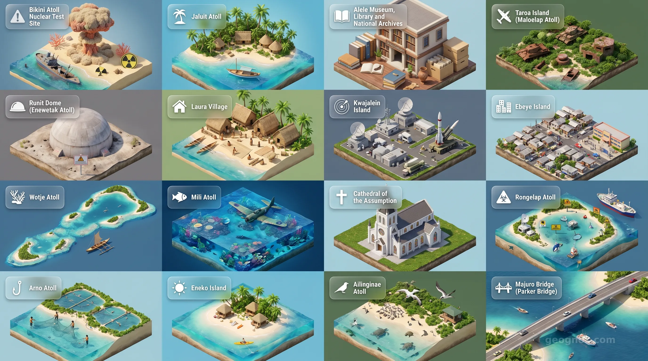
Bikini Atoll stands as a solemn testament to the dawn of the nuclear age, famous as the primary testing ground for the United States' atomic weapons program between 1946 and 1958. For students of modern history and environmental science, it provides an unparalleled case study of geopolitical impact and ecological resilience. Visitors can dive among the 'Ghost Fleet,' a collection of sunken WWII warships used as targets during Operation Crossroads. The best season to visit is between May and October when the seas are calmest. Tourist tip: Access is highly restricted, requiring special permits, and diving is limited strictly to highly experienced technical divers via specialized liveaboard charters.
Former Colonial Capital
Jaluit Atoll was the administrative center of the Marshall Islands during both the German colonial era and the Japanese mandate prior to World War II. History enthusiasts will be fascinated by the remnants of colonial architecture, ancient trading posts, and abandoned Japanese military bunkers scattered across the islets. The atoll is also recognized on the UNESCO tentative list for its pristine mangrove forests and diverse marine life. The optimal time to explore is during the dry season from December to April. Tourist tip: Tourist infrastructure is minimal; bring your own snorkeling gear and arrange boat transfers with local guesthouses well in advance.
Heart of Marshallese Culture
Located in the capital of Majuro, the Alele Museum is the premier institution for studying the indigenous culture of the Marshall Islands. It houses rare artifacts, traditional clothing, intricately designed outrigger canoes, and the famous stick charts—ancient navigational tools used by Marshallese seafarers to read ocean swells. It is an essential first stop for students of anthropology and curious tourists wanting to understand the islanders' deep connection to the ocean. It can be visited year-round. Tourist tip: The museum's gift shop is the best place in the country to purchase authentic, locally made handicrafts, directly supporting indigenous artisans.
WWII Japanese Airbase Ruins
Taroa Island serves as a haunting, open-air museum of the Pacific War. Once a major Japanese airbase, the island is now covered in lush jungle that intertwines with rusting Mitsubishi Zero fighter planes, anti-aircraft guns, pillboxes, and concrete bunkers. It is a vital site for military historians studying the Pacific theater. The contrast between the violent history and the peaceful, recovering natural landscape makes it incredibly profound. The dry season from December to April is the best time to navigate the trails. Tourist tip: Always stay on marked paths and hire a local guide, as unexploded ordnance (UXO) is still a hazard in off-trail areas.
The Tomb of Nuclear Waste
Colloquially known as 'The Tomb', Runit Dome is a massive concrete shell built over a crater to contain radioactive soil and debris from 43 nuclear tests conducted on Enewetak Atoll. For environmental scientists, sociologists, and historians, it is a chilling monument to the lingering consequences of the Cold War. As sea levels rise, the dome is becoming a focal point for global climate change studies. Due to its nature, there is no 'tourist season' per se, and visitation is incredibly difficult. Tourist tip: Travel here requires complex government permissions and radiation safety protocols; it is strictly an expedition for serious researchers and journalists.
Ancient Settlement and Pristine Beach
Situated at the westernmost tip of Majuro Atoll, Laura Village is the agricultural heart of the capital and features some of the oldest continuous settlement sites in the Marshall Islands, dating back thousands of years. It offers a stark, tranquil contrast to the heavily urbanized eastern end of the atoll. Students of sociology can observe traditional Marshallese subsistence farming and relaxed island life here. The beaches at Laura point are renowned for their white sand. It is an excellent year-round destination. Tourist tip: Pack a picnic and head to Laura Beach Park for the day, but remember to pay the small, customary entrance fee to the local landowners.
Strategic Military Hub
Kwajalein Island is the largest island in the Kwajalein Atoll and serves as an active US Army Garrison and missile testing facility (Ronald Reagan Ballistic Missile Defense Test Site). Historically, it was the site of the Battle of Kwajalein in 1944. Today, it presents a fascinating study of geopolitical strategy and modern military logistics existing alongside tropical coral reefs. Weather is consistent year-round, making any time a good time to visit if permitted. Tourist tip: Kwajalein is a restricted military base. You cannot visit without official US military sponsorship, though transit passengers can view it from the airport terminal.
The Pacific's Most Densely Populated Island
Located just three miles from Kwajalein, Ebeye Island is home to over 15,000 people living on just 80 acres of land. Often studied by urban planners and sociologists, Ebeye illustrates the profound impacts of forced migration (due to nuclear testing and military base expansion) and the challenges of urbanization in small island developing states. While not a traditional tourist destination, it offers deep educational value regarding post-colonial Pacific realities. It can be visited year-round. Tourist tip: Visitors can take the daily ferry from Kwajalein, but must dress modestly and navigate the island with deep respect for the residents' privacy.
Relics of the Japanese Pacific Fleet
Wotje Atoll was a major seaplane base for the Imperial Japanese Navy during WWII. Today, the main island is littered with heavy artillery, power stations, and ruined military headquarters slowly being swallowed by banyan trees and jungle vines. It is a spectacular site for historians looking to study WWII architecture and the resilience of nature reclaiming man-made destruction. The best time to visit is from December to April. Tourist tip: Reaching Wotje requires taking Air Marshall Islands domestic flights, which are prone to schedule changes, so build flexibility into your itinerary.
Site of the WWII Mili Mutiny
Mili Atoll holds a dark but fascinating WWII history, being the site of a rare mutiny by Korean conscripts against the Japanese military in 1945. It is incredibly rich in untouched wartime artifacts, including intact artillery batteries and a downed B-25 bomber resting in the shallow lagoon. Additionally, its untouched beaches and coral reefs offer breathtaking natural beauty. The dry season (December-April) offers the best conditions for exploring both the jungle and the lagoon. Tourist tip: Accommodation is entirely homestay-based; bringing practical gifts (like fishing gear or school supplies) for your host family is highly appreciated.
Spiritual Center of Majuro
Constructed in 1898 and subsequently rebuilt, the Cathedral of the Assumption is a prominent architectural and cultural landmark in Majuro. As the seat of the Apostolic Prefecture of the Marshall Islands, it reflects the deep historical impact of Christian missionaries in Micronesia. Students of theology and architecture will appreciate its high, sweeping roof designed to mimic traditional Marshallese structures while enduring typhoon winds. It is accessible year-round. Tourist tip: Attend a Sunday morning service to hear the breathtaking, a cappella Marshallese choral singing, regardless of your personal religious affiliations.
A Pristine Shark Sanctuary
Rongelap Atoll suffered tragically from the radioactive fallout of the Castle Bravo nuclear test in 1954, forcing the evacuation of its people. Today, devoid of human habitation for decades, its marine environment has bounced back to become one of the most pristine coral reef ecosystems on Earth, designated as a shark sanctuary. It offers an unparalleled opportunity for marine biologists to study ecosystem recovery. The best visiting season is the summer months for calmer seas. Tourist tip: Due to lingering radiation concerns on land and total lack of infrastructure, Rongelap can only be visited via highly specialized marine liveaboard expeditions.
The 'Love School' Atoll
Comprising 133 islands, Arno Atoll is famous in Marshallese folklore as the site of the ancient 'Love School,' where young women were traditionally taught the arts of romance and courtship. Today, it is known for its copra (dried coconut) production and magnificent, sweeping beaches that offer a glimpse into traditional outer-island life. Because it is located incredibly close to Majuro, it is a highly accessible study site for agritourism and local economics. Best visited from December to April. Tourist tip: Arno is just a 45-minute boat ride from Majuro, making it the perfect day-trip for tourists wanting to escape the capital's hustle.
Majuro's Tropical Escape
Eneko Island is a small, privately-owned islet within the Majuro Atoll, providing a picturesque tropical getaway. While lacking the heavy historical significance of other atolls, it serves as an excellent case study in local eco-tourism and sustainable small-scale hospitality in Micronesia. The turquoise waters and vibrant coral gardens make it a premier snorkeling destination. It is an excellent year-round destination due to the sheltered lagoon. Tourist tip: Day passes and overnight stays in their eco-cabins must be booked in advance through the Robert Reimers Hotel in Majuro.
Untouched Marine Wilderness
Currently on the UNESCO tentative list, Ailinginae Atoll is an uninhabited coral atoll recognized for its undisturbed biodiversity. It serves as a critical nesting site for green sea turtles and numerous species of seabirds. For environmental science students, it represents a global baseline for what a healthy, unimpacted coral reef ecosystem looks like. The best time to visit is from May to October when ocean conditions allow for safe passage. Tourist tip: There are no facilities of any kind here; visitors must be entirely self-sufficient, typically arriving via private yacht or specialized charter.
The Highest Point in Majuro
The Majuro Bridge, officially the Parker Bridge, connects the islets of Delap, Uliga, and Darrit (the D-U-D area). It is the highest elevation point on the entire Majuro atoll, originally built to allow boats to pass underneath while accommodating the growing vehicular traffic of the capital. It represents the modernization and infrastructural development of the country post-WWII. Year-round accessibility. Tourist tip: Take a walk to the top of the bridge during sunset; it offers one of the few elevated, panoramic vantage points for photography in the entire country.